The Rest of the Week…
Glancing at the alert map we now have Winter Storm Warnings posted for most of the northern 1/3rd of the state, down to along the US 20 corridor, and as far down as the US 30 corridor in eastern Iowa from around Benton County east to the Mississippi River. A Winter Weather Advisory is in effect for the remainder of the US 30 corridor west of Benton County and much of the I-80 corridor as well as the I-29 corridor north of US 30.
It’s been a couple days and a dozen model runs since I wrote my rough forecast post for the convention I’m traveling to tomorrow (Thursday) so I’m going back and updating things.
Thursday
Breakfast (7 AM): Mid to Upper 30s
Lunch (1 PM): Low 50s
Evening (7 PM): Low 50s
Overnight (1 AM Friday): Low 40s
Friday
Breakfast: Mid to Upper 30s
Lunch: Mid 50s
Evening: Upper 50s
Overnight (1 AM Saturday): Upper 40s
Saturday
Breakfast: Mid 40s
Lunch: Upper 40s to Low 50s chance of rain
Evening: Low 50s
Overnight (1 AM Sunday): Upper 40s
Sunday
Breakfast: Lower to Mid 40s
Lunch: Now that we’re closer things are looking more consistent. Mid to Upper 50s.
The Week Ahead..
So I’m taking a short (3hr) road trip south later this week into the weekend so I thought I would work out a forecast and share it. We’re a few days out yet and most of this is based on only one model (US GFS) so it may well change between now and then.
Thursday
Breakfast (7 AM): Upper 30s
Lunch (1 PM): Mid 50s
Evening (7 PM): Upper 50s
Overnight (1 AM Friday): Mid to Upper 40s
Friday
Breakfast: Low to Mid 40s
Lunch: Mid 50s
Evening: Upper 50s, possibly a chance of rain in which case temps in low 50s
Overnight (1 AM Saturday): Upper 40s to Low 50s, possible chance of rain
Saturday
Breakfast: Mid 40s, chance of rain
Lunch: Mid to Upper 40s, chance of rain
Evening: Mid 40s
Overnight (1 AM Sunday): Lower 40s
Sunday
Breakfast: Lower 40s
Lunch: Things aren’t so consistent here. Upper 40s to around 60.
Henry just put up a write-up on the next round of winter weather for northwest & north central Iowa so I won’t rehash that here.
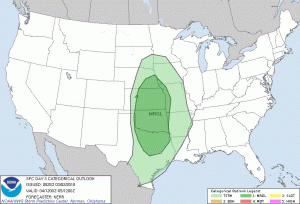
Winter Storm/Severe Weather 4/13/18
So it’s Friday the 13th.
Looking at today’s forecast for the state, it’s pretty much all the storms (which of them depends on your exact location). We could see rain, hail, snow, tornadoes, blizzards.. you get it. I have a meeting after work so I will not be out chasing anything and most likely helping with things over at Iowa Weather Network once the meeting wraps up.
Winter Storm 2/19-20
Today
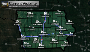
Okay so today we have a Wind Advisory going into effect at 9 AM until 2 PM this afternoon for a good chunk of the state for sustained winds of 30 MPH with gusts up to 45 MPH. We also have a Dense Fog Advisory for east central Iowa until 10 AM.
Monday & Tuesday
Two rounds of freezing rain will move through the state with some areas seeing around a tenth of an inch, while others may see more significant icing with accumulations of around a quarter to half of an inch, potentially resulting in power outages and tree damage. The areas with the greatest icing potential have had Winter Storm Watches posted. More details will be coming later today.
Current Advisories by County
Monona, Woodbury, Plymouth, Sioux – Winter Weather Advisory from 12 AM to 12 PM Monday
Osceola, Dickinson, O’Brien, Clay, Cherokee, Buena Vista, Ida – Wind Advisory from 9 AM to 2 PM Today, Winter Weather Advisory from 12 AM tonight to 12 PM Monday
Emmet, Kossuth, Winnebago, Worth, Palo Alto, Hancock, Cerro Gordo, Pocahontas, Humboldt, Wright, Franklin, Sac, Calhoun, Webster, Hamilton, Crawford, Carroll, Greene, Boone, Audubon, Guthrie – Wind Advisory from 9 AM to 2 PM Today, Winter Weather Advisory from 12 AM tonight until 3PM Monday
Butler, Bremer, Hardin, Grundy, Black Hawk, Story, Marshall, Dallas, Polk, Jasper, Madison, Warren, Union, Clarke, Ringgold, Decatur – Wind Advisory from 9 AM to 2 PM Today, Winter Storm Watch from Monday Evening to Tuesday Morning
Tama, Poweshiek, Marion, Lucas – Winter Storm Watch from Monday Evening to Tuesday Morning
Mitchell, Floyd – Wind Advisory from 9 AM this morning to 3PM this afternoon, Winter Weather Advisory from 12 AM tonight to 6 PM Tuesday
Howard, Winneshiek, Chickasaw – Wind Advisory from 9 AM this morning to 3PM this afternoon, Winter Storm Watch from Monday Morning through Tuesday Afternoon
Allamakee, Fayette, Clayton – Winter Storm Watch from Monday Afternoon through Tuesday Afternoon
Net Neutrality III – Grassley Response
So I received an email from Senator Grassley yesterday regarding Net Neutrality.
Winter Storm Update 2
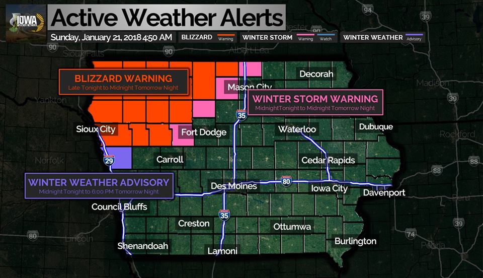
The NWS in Des Moines sent out an update after the previous post went live. The map above shows the latest warnings and advisories, thanks to Henry over at Iowa Weather Network.
1/21-23 NW IA Winter Storm Update
Just a short post as the National Weather Service just released some updates regarding the approaching winter storm.
The Winter Storm Watch in effect for northwest Iowa has been upgraded to a Blizzard Warning which goes into effect at 9 PM tonight until midnight Monday night (Tuesday morning) for the following counties: Plymouth, Lyon, Osceola, Dickinson, Sioux, O’Brien, Clay, Cherokee, Buena Vista, Ida, and Woodbury. This warning includes the entire Sioux City metro area (IA/SD/NE).
The Winter Storm Watch in effect for Monona County has been upgraded to a Winter Weather Advisory which goes into effect at midnight tonight until 6 PM Monday.
Winter Storm Warning remains in effect from 9 PM Sunday until midnight Monday night (Tuesday morning) for Emmet, Kossuth, and Palo Alto counties in Iowa.
Brrr..
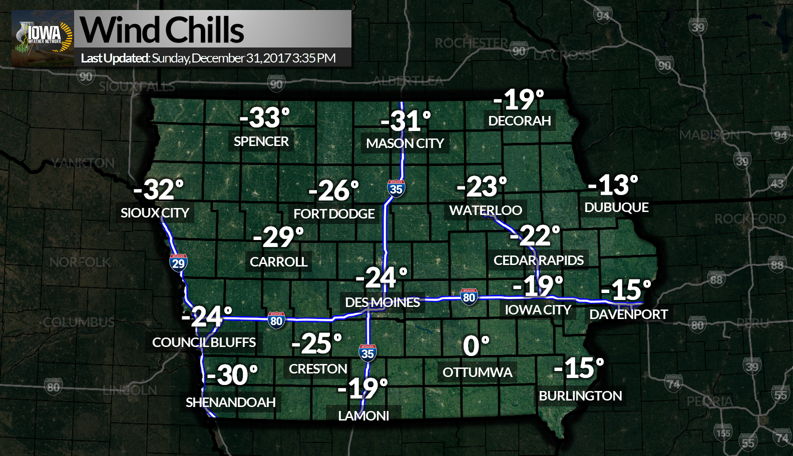
I think this graphic from earlier says it all. If you’re out celebrating this evening stay safe and have a happy new year!
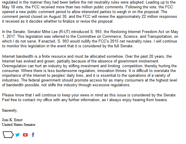
Net Neutrality II – King, Ernst Responses
Unfortunately the FCC lost it’s mind this morning and voted to roll back the Net Neutrality rules, which so far seems to be supported by Iowa’s Congressional delegation. Responses from both Senator Ernst and Representative King are below. I’m told Representative Blum gave a similar response to one of his constituents. I have yet to hear anything from Senator Grassley.
I previously posted the letters on Facebook but decided to add them here as well..but since they were in email I had a hard time figuring out how to extract them.
Comments from Sen. Ernst – 11/22/17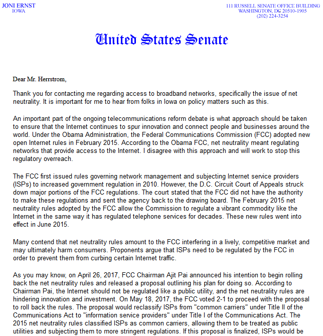
Comments from Rep. Steve King – 11/27/17