AMBER Alert Cancelled
The AMBER Alert from the previous post has been CANCELLED. According to the Iowa State Patrol the child was located in Cedar Rapids.
Mandatory Evacuation in Urbandale – Gas Leak
Urbandale residents within a quarter-mile radius of 142nd Street & Oak Brook Drive are being ordered by police to evacuate their homes due to a gas main that was struck by a contractor working in the area. Those without anywhere to go are being directed to the Urbandale Fire Station 42 at 3927 121st Street according to the Des Moines Register.
Severe Weather Possible Today
Severe weather will be possible this afternoon and evening with all modes of severe weather possible. The outlook from the Storm Prediction Center in Oklahoma shows the possibility for severe weather exists over most of Iowa and into portions of neighboring states. Hopefully I will be able to post further updates this afternoon.


Tornado Watch Likely
The Storm Prediction Center is expecting to issue a Tornado Watch for central & eastern Iowa within the hour. Stay tuned for updates.
Eastern Iowa Upgraded to HIGH RISK of Severe Weather


SPECIAL WEATHER STATEMENT
NATIONAL WEATHER SERVICE QUAD CITIES IA IL
1052 AM CDT WED JUN 12 2013
IAZ040>042-051>054-063>068-076>078-087>089-098-099-ILZ001-002-007-
009-015>018-024>026-034-035-121800-
WASHINGTON IA-VAN BUREN IA-SCOTT IA-MUSCATINE IA-LOUISA IA-LINN IA-
LEE IA-KEOKUK IA-JOHNSON IA-JEFFERSON IA-JACKSON IA-IOWA IA-HENRY IA-
DUBUQUE IA-DES MOINES IA-DELAWARE IA-BENTON IA-BUCHANAN IA-CEDAR IA-
CLINTON IA-JONES IA-JO DAVIESS IL-HENRY IL-MCDONOUGH IL-MERCER IL-
PUTNAM IL-ROCK ISLAND IL-STEPHENSON IL-WARREN IL-WHITESIDE IL-
BUREAU IL-CARROLL IL-HENDERSON IL-HANCOCK IL-
1052 AM CDT WED JUN 12 2013
…HIGH RISK FOR SEVERE WEATHER ACROSS EASTERN IOWA AND NORTHWEST
ILLINOIS THIS AFTERNOON…
INGREDIENTS ARE COMING TOGETHER SUPPORTING A HIGH THREAT FOR SEVERE
THUNDERSTORMS WITH DAMAGING WINDS…LARGE HAIL AND TORNADOES OVER
MUCH OF EASTERN IOWA…WEST CENTRAL AND NORTHWEST ILLINOIS THIS
AFTERNOON.
SUPERCELL THUNDERSTORMS ARE EXPECTED TO DEVELOP BETWEEN NOON AND 3
PM OVER PORTIONS OF EASTERN IOWA AND NORTHWEST ILLINOIS. THESE
STORMS WILL BE CAPABLE OF PRODUCING WINDS OVER 70 MPH…LARGE HAIL
AND TORNADOES…WITH MOVEMENT TO THE EAST AROUND 40 TO 50 MPH.
INDIVIDUAL STORMS ARE EXPECTED TO ORGANIZE INTO A LINE OF STORMS
WITH WIDESPREAD DAMAGING WIND AS THEY EXIT EAST ACROSS
NORTHERN ILLINOIS FROM MID TO LATE AFTERNOON.
A TORNADO WATCH WILL LIKELY BE ISSUED FOR THE AREA THIS AFTERNOON.
WHILE THE THREAT OF SEVERE WEATHER IS NOT IMMINENT…THIS IS A
POTENTIALLY DANGEROUS SITUATION AND YOU SHOULD MAKE PLANS FOR WHERE
YOU WILL TAKE SHELTER IF WARNINGS ARE ISSUED. CLOSELY MONITOR NOAA
WEATHER RADIO OR LOCAL MEDIA OUTLOOKS FOR FURTHER UPDATES AND
WARNINGS.
SHEETS
Storm Chances Today
I plan to depart for southwestern Iowa shortly, follow the links below for the latest information on today’s severe weather threat. The live coverage link will have my video stream as well as here on my website.
Latest information via Iowa Weather Network: Facebook – Twitter – Google+ – Live Coverage
Watch Likely for Western Iowa
A Severe Thunderstorm Watch is likely for Western Iowa, areas along and west of US Highway 71, for damaging wind potential and possibly some large hail as storms ongoing in Nebraska and Iowa make their way into the state.The area circled in red on the map below is the area being considered for the watch.
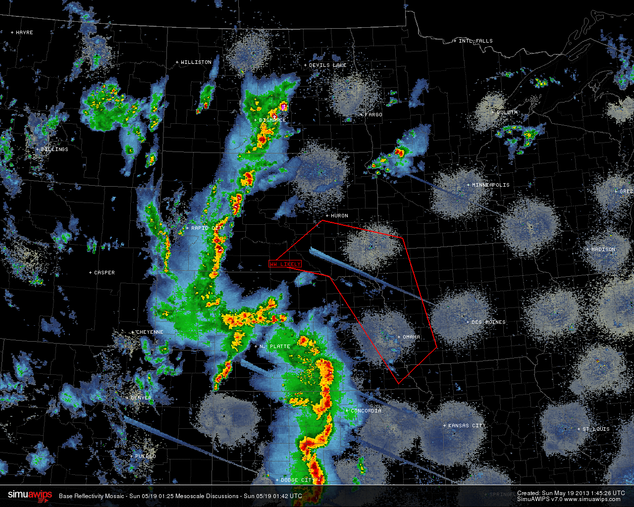
I’m currently sitting in Sioux City in advance of tomorrows severe weather potential, with the whole state having a chance at severe weather.
Updates
I have been terrible about keeping this updated lately. I am looking at chasing this weekend, but haven’t ironed out the details yet. It does however appear that anyone with outdoor plans for this weekend into Monday in Iowa and surrounding states should keep an eye on the weather.
Red Flag Warning for Boone, Dallas Counties until 8 PM
…DANGEROUS FIRE WEATHER CONDITIONS THIS AFTERNOON…
.STRONG SOUTH TO SOUTHWEST WINDS OF 20 TO 25 MPH AND GUSTS TO NEAR
40 MPH…COMBINED WITH VERY LOW RELATIVE HUMIDITY WILL RESULT IN
DANGEROUS FIRE WEATHER CONDITIONS OVER MUCH OF NORTHERN AND
WESTERN IOWA BY THIS AFTERNOON AND INTO THE EARLY EVENING.
…RED FLAG WARNING IN EFFECT FROM NOON TODAY TO 8 PM CDT THIS
EVENING…
THE NATIONAL WEATHER SERVICE IN DES MOINES HAS ISSUED A RED FLAG
WARNING FOR EXTREME FIRE CONDITIONS…WHICH IS IN EFFECT FROM
NOON TODAY TO 8 PM CDT THIS EVENING. THE FIRE WEATHER WATCH IS NO
LONGER IN EFFECT.
* TIMING…THE RELATIVE HUMIDITY WILL DIP BELOW 25 PERCENT BY NOON
AND CONTINUE TO DECREASE DURING THE AFTERNOON. THE LOWEST
RELATIVE HUMIDITY AND THE STRONGEST WINDS ARE EXPECTED BETWEEN 1
PM AND 5 PM TODAY.
* AFFECTED AREA…WEST CENTRAL TO NORTH CENTRAL IOWA.
* WIND…SOUTH TO SOUTHWEST WINDS OF 20 TO 25 MPH WITH GUSTS AS
HIGH AS 40 MPH ARE POSSIBLE BY THIS AFTERNOON.
* RELATIVE HUMIDITY…AS LOW AS 17 PERCENT.
* FUEL…MANY WILD GRASSES ARE NOT FULLY GREEN AS A RESULT OF THE
LATE SPRING AND COULD POTENTIALLY BURN MORE EASILY THAN IS
TYPICAL FOR THIS TIME OF YEAR.
* IMPACTS…FIRES WILL SPREAD QUICKLY IN THESE DANGEROUS
CONDITIONS AND BURNING IS STRONGLY DISCOURAGED.
PRECAUTIONARY/PREPAREDNESS ACTIONS…
A RED FLAG WARNING MEANS THAT CRITICAL FIRE WEATHER CONDITIONS
ARE EITHER OCCURRING NOW…OR WILL SHORTLY. A COMBINATION OF
STRONG WINDS…LOW RELATIVE HUMIDITY…AND WARM TEMPERATURES CAN
CONTRIBUTE TO EXTREME FIRE BEHAVIOR.
From Drought to Flood
The weather in the state is fairly active this morning as shown on the watch/warning map below.
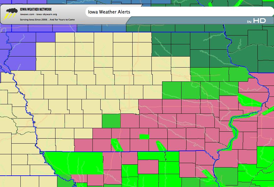
Severe Thunderstorm Watch is in effect for portions of south central, southeast, and east central Iowa into adjacent portions of Missouri and Illinois until 5 PM. Recent rainfall has reduced, if not resolved the drought conditions in portions of the state with flood watches and warnings now in effect in many areas including parts of the Mississippi.